
Blog
How Veridion’s Data Improves the Accuracy of Climate Risk Models
By: Auras Tanase -
03 April 2026


We love our data, and now that you're here, you're one step closer to loving it too.
A wide sample of data, so you can explore what is possible with our data
Choose ->
built with procurement in mind. Focused on manufacturers, products and more
Choose ->
built with insurance in mind. Focused on classifications, business activity tags and more
Choose ->
built with sustainability in mind. Focused on sustainability commitments, and environmental and social governance insights.
Choose ->
built with strategic insights in mind. Focused on market trends, competitor analysis, and industry-specific data
Choose ->

Keep up to date with our technology, what our clients are doing and get interesting monthly market insights.

Climate risk models have never been more precise.
They can simulate wildfire spread block by block, estimate flood depth at the building level, and project wind intensity with remarkable accuracy.
But hazard precision does not automatically translate into financial precision.
A wildfire does not damage “commercial property.” It disrupts semiconductor plants, logistics hubs, medical centers, and R&D facilities.
And if a model cannot distinguish between those functions, its loss estimates will be structurally incomplete.
That is where Veridion’s data changes the game.
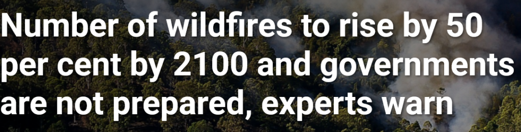
Climate hazards are intensifying.
According to a joint assessment by the United Nations Environment Programme and GRID-Arendal, extreme wildfires could increase by 14% by 2030, 30% by 2050, and up to 50% by the end of the century.
Source: UNEP
The probability layer of climate models is becoming more volatile.
But probability alone does not define risk. Exposure does.
Most climate risk models answer one question extremely well: Where will the hazard strike?
They are less equipped to answer: What exactly operates at that location?
Two buildings in the same flood zone can look identical in satellite imagery. Both may be labeled “industrial.”
Yet one could be a low-value storage facility, while the other houses advanced manufacturing, proprietary research, or a single-source supplier embedded in multiple global supply chains.
In climate risk models, that distinction directly affects loss severity.
We have seen how operational function reshapes impact.
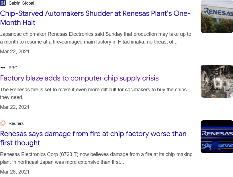
When a fire damaged a semiconductor facility operated by Renesas Electronics in 2021, the physical footprint of the event was limited.
The operational consequences were not. Automotive production slowed globally for months.
Source: Google
The event was not climate-driven, but it illustrates a universal truth: When function is underestimated, systemic risk is underestimated.
This is where Veridion comes in.
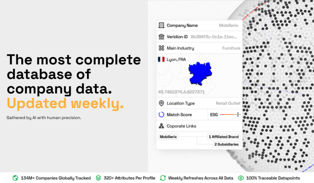
Veridion is a global location intelligence provider covering more than 130 million companies across 250+ countries and territories.
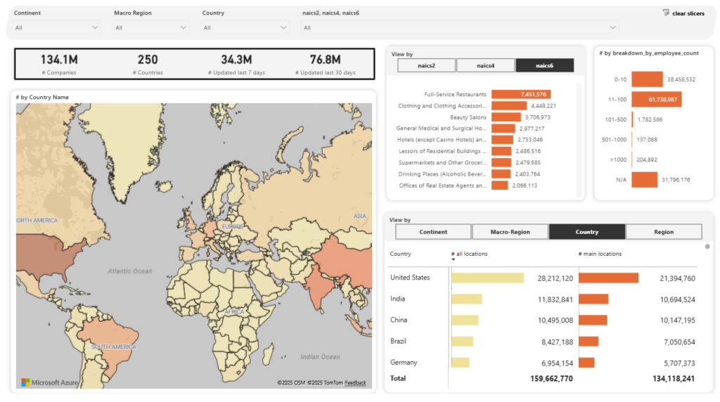
Source: Veridion
Its dataset is built by continuously aggregating and validating structured and unstructured data from:
With the help of AI and machine learning, Veridion delivers a dynamically updated map of where companies actually operate.
Instead of relying solely on registered addresses or generic industry codes, it identifies secondary facilities, production sites, R&D centers, distribution hubs, and co-located entities.
In other words, it classifies each site by operational function.
Not simply “commercial” or “industrial,” but:
That functional layer materially strengthens the exposure component of climate risk models.
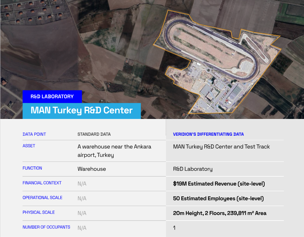
Consider a facility near Ankara Airport.
In conventional datasets, it appears as a generic warehouse.
Veridion’s analysis identified it as the MAN Turkey R&D Center, a research and testing site supporting engineering and innovation activities.
Source: Veridion
Using site-level modeling, Veridion estimated approximately $19 million in site-attributed revenue, around 50 employees, and a 239,000+ m² footprint.
From a hazard perspective, it is a coordinate within a risk zone, but from an exposure perspective, it is a mission-critical innovation node.
Without operational classification, a climate model may estimate structural damage correctly while materially underestimating economic disruption.
Veridion also captures another frequently overlooked dimension: shared-site risk.
Industrial parks and multi-tenant facilities often host multiple companies within the same physical structure (and are on the rise).
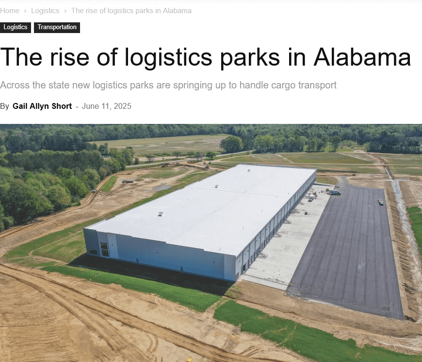
Source: Business Alabama
Traditional datasets treat these entities separately because they share an address but not necessarily ownership records.
What appears diversified at the portfolio level may, in reality, be geographically concentrated.
Veridion identifies co-tenants operating within the same footprint and maps occupancy signals to distinguish between sole occupancy and leased space.
That changes correlation modeling.
If a flood disables a shared industrial complex, multiple suppliers may be disrupted simultaneously.
To sum up, by integrating operational function, co-tenancy, and occupancy structure, Veridion changes climate risk models.
With Veridion’s rich context, models begin modeling economic systems rather than isolated properties.
Improving exposure accuracy changes real financial outcomes.
Global catastrophe losses have risen steadily over the past decade.
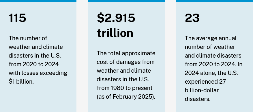
Source: COAST NOAA
Severe convective storms alone have generated tens of billions in insured losses in recent years.
Wildfires, once a marginal contributor to global catastrophe losses, now represent a materially larger share of annual insured damage.
As losses increase, the cost of misclassification increases with them.
A climate model may estimate that a facility sits in a high-probability flood or wildfire corridor.
But decision-makers need more than probability. They need financial data, including:
This is where Veridion adds precision.
Because Veridion links site-level revenue, employee counts, operational function, and corporate hierarchy to exact coordinates, hazard outputs can be translated into value-at-risk, not just property damage.
Take a warehouse facility in Edmonton.
In many datasets, it appears as a generic logistics building. Veridion identified it specifically as a parts distribution center operated by General Motors.
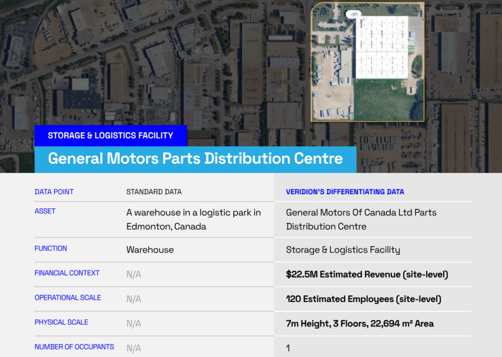
Source: Veridion
Estimated site-level metrics included:
Structurally, it is storage. But operationally, it is a supply chain hub.
A 48-hour disruption caused by severe winter storms would not simply affect inventory but could also delay vehicle servicing and parts distribution across multiple regions.
That cascading impact does not appear in models that rely only on building type.
The same dynamic becomes clearer at scale.
In a recent wildfire analysis of Los Angeles County powered by Veridion’s dataset, approximately 65,000 companies and 527,000 employees were identified within affected zones.
Estimated revenue exposure reached roughly $115 billion.
The majority of impacted businesses were in services, followed by retail and manufacturing. Medical facilities, offices, and retail locations represented a significant share of exposure.
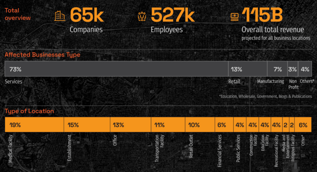
Source: Veridion
This changes how we interpret the event.
It is no longer just acreage burned or insured property damage. It is a measurable economic disruption:
Better exposure data flows directly into better financial modeling.
When operational function, revenue, workforce size, and corporate interdependencies are embedded into climate risk models, loss estimates move closer to economic reality.
When operational intelligence is integrated into climate models, it expands what the model can actually do.
Traditional climate risk modeling focuses on hazard probability and structural exposure.
With verified operational data layered in, the model begins to evaluate economic networks.
This unlocks new analytical capability.
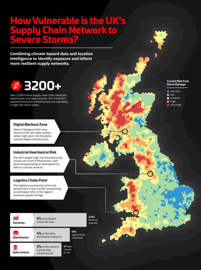
Consider a recent UK supply chain analysis powered by Veridion’s dataset.
More than 67,000 company locations were overlaid with storm hazard maps.
The results identified over 3,200 critical infrastructure sites located in high-risk zones, including factories, logistics hubs, and data centers.
Source: Veridion on LinkedIn
What looks diversified at a national level revealed concentrated vulnerability at the operational level.
That type of insight supports more than underwriting. It enables system-level stress testing.
It also supports regulatory and ESG reporting.
Frameworks such as the EU’s Corporate Sustainability Reporting Directive (CSRD) and Corporate Sustainability Due Diligence Directive (CSDDD) increasingly require asset-level transparency around climate exposure and operational risk.
High-level industry classification is no longer sufficient.
Granular site-level data, including function, workforce size, revenue estimates, and corporate linkage, becomes essential.
And because Veridion’s dataset is continuously refreshed, it captures operational changes in near real time: facility openings, closures, expansions, secondary sites, and subsidiary networks.
Source: Veridion
That matters.
Climate exposure is not static. Corporate footprints are not static. A model built on outdated location data quickly loses reliability.
By combining hazard layers with continuously validated operational intelligence, climate risk models move from static mapping tools to decision engines.
In short, the model is no longer evaluating a coordinate in isolation. It is evaluating an economic node within a network.
That is where real business value emerges.
Climate models are increasingly precise in predicting where hazards will occur. But financial accuracy depends on understanding what operates inside each location.
As catastrophe losses rise and regulatory expectations tighten, exposure misclassification becomes a liability.
By embedding continuously validated operational intelligence into climate risk models, Veridion transforms hazard mapping into economic insight.
And in today’s climate environment, that level of precision is no longer optional.